The Data Directory
Decision Theatre reads all of its content from a data directory, passed with --data-dir and defaulting to ./data. This page describes exactly what the application looks for there, cross-referenced to the code that reads it, so an administrator can tell what is required, what is optional, and what does not belong.
Every path below was verified against the Go source. Where a filename is hardcoded, that is stated — those files cannot be renamed.
Check before you run
Rather than working through this page by hand, run the validator:
Required for the application to work
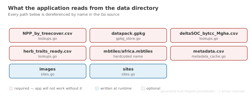
filepath.Join(dataDir, …) in the Go source, so this cannot fall behind the code that reads these files. | Path | Read by | Notes |
|---|---|---|
datapack.gpkg | internal/geodata/gpkg_store.go | Filename is hardcoded. No other name is discovered. |
mbtiles/africa.mbtiles | internal/tiles/mbtiles.go | Must be named africa — see the warning below. |
mbtiles/style.json | internal/server/server.go | Required — see the note below. |
metadata.csv | internal/api/metadata_cache.go | Indicator display metadata. |
NPP_by_treecover.csv | internal/api/lookups.go | Needs a catchID column. |
deltaSOC_bytcc_Mgha.csv | internal/api/lookups.go | Needs a catchID column. |
herb_traits_ready.csv | internal/api/lookups.go | Herbivore trait lookup. |
The style belongs to the data pack, not the application
The server currently falls back to <resources-dir>/mbtiles/style.json when the data directory has no style. Do not rely on this — it is being removed.
The style is dataset-specific: its layers name the source-layers of one particular tileset (ne_african_countries, ecoregions, WDPA_Feb2026_Public and others). Falling back therefore substitutes a different dataset's cartography for the one you installed; against a tileset with different layer names every layer resolves to nothing and the map renders blank, with no error logged.
Treat mbtiles/style.json as required. A data pack without one is incomplete.
Ticket: Remove the --resources-dir flag and the style.json fallback.
The tileset must be named africa
The tileset name is derived from the filename with .mbtiles stripped (mbtiles.go: strings.TrimSuffix(entry.Name(), ".mbtiles")). The server then hardcodes the name africa in three places — WarmCache (server.go:117), handleTileJSON (server.go:383) and GetMetadata (server.go:394) — and /data/tiles.json always advertises /tiles/africa/{z}/{x}/{y}.pbf.
A file named africa-002.mbtiles therefore registers a tileset called africa-002 that nothing ever requests, and the map renders blank. Rename it:
Tile files are searched for in both data/ and data/mbtiles/.
GeoPackage structure
datapack.gpkg must contain:
| Object | Purpose |
|---|---|
catchments_lev12 | Catchment geometry, with HYBAS_ID and HYBAS_ID_int columns |
scenario_current | Current-scenario attribute values, joined on catchment_id_int |
scenario_reference | Reference-scenario attribute values |
rtree_catchments_lev12_geom | Spatial index; without it, viewport queries degrade to full scans |
Optional, enabling whisker bounds in charts: scenario_current_lower, scenario_current_upper, scenario_reference_lower, scenario_reference_upper.
metadata.csv and column-name matching
metadata.csv is keyed on ColumnName, and the lookup is an exact string match against the column names in the GeoPackage scenario tables. A row whose ColumnName does not match a real column is silently ignored, and the corresponding indicator will:
- render with its raw column name,
- have no colour, units or axis label,
- have no chart-type detection, and
- not appear in the map or chart selectors at all, because the
MapthisYNandgraphthisYNlookups miss.
Watch for dots where the data has spaces
If metadata.csv is exported from R without care, make.names() rewrites spaces to dots — so the CSV says Obligate.grazer where the GeoPackage says Obligate grazer. The names look correct to a human and match nothing at runtime.
This is not hypothetical: in the data directory as currently supplied, 344 of 503 metadata rows fail to match for exactly this reason, and only 159 resolve. The validator detects and reports this case specifically.
When exporting from R, read with check.names = FALSE and write with write.csv(x, "metadata.csv", row.names = FALSE).
For the full column-by-column reference, see Datapack Format.
Runtime directories
These are written to while the application runs. They are created on demand, but their parent must be writable.
| Path | Purpose |
|---|---|
sites/ | Site JSON files (desktop runtime only; the browser runtime uses local storage) |
images/ | Site thumbnails, served at /data/images/ |
Optional content
| Path | Purpose |
|---|---|
walkthroughs/*.json | Read-only demo sites backing the guided tours, served at /data/walkthroughs/ |
demo/ | Assets used by the tours, e.g. Munywana_dissolved_fixed.zip |
Each walkthrough file's name must equal the id field inside it, and both must match an entry in frontend/src/constants/walkthroughSites.ts. All three are checked by the validator.
Data pipeline inputs
These are consumed by scripts/build-geopackage.sh to produce datapack.gpkg. They are not read at runtime and do not need to be shipped in a distributed data pack — they account for roughly 2 GB.
| Path | Role |
|---|---|
catchments.gpkg | Source catchment geometry |
current.csv, current_lower.csv, current_upper.csv | Current-scenario values and bounds |
reference.csv, reference_lower.csv, reference_upper.csv | Reference-scenario values and bounds |
Keeping them alongside the runtime data is reasonable on a workstation that rebuilds the GeoPackage. Omit them when packaging for distribution — see Data Preparation.
What should not be in the data directory
The validator reports these as warnings. None of them break the application; they inflate the directory and confuse its purpose.
| Path | Why it does not belong |
|---|---|
R scripts/ | Source code, not data. It belongs in version control alongside the rest of the analysis code, not in a directory that is deliberately untracked and shipped to users. |
R scripts/.Rhistory | A personal R console history file. It records one developer's interactive session and should simply be deleted. |
R scripts/OldFiles/ | Superseded scripts. Version control is the place for history. |
R scripts/GrazingIntensity_calcs/Screenshot ….jpg | A screenshot committed alongside calculation inputs. |
mbtiles/uow_tiles.json | Legacy tile descriptor. The server only ever reads mbtiles/style.json. |
mbtiles/style-catchments-cropped.json | An alternate style that nothing loads. Keep it only if it is being actively worked on. |
old_data/ | Superseded data. Remove rather than ship. |
Why this matters
The data directory is untracked by design and is distributed to users as a data pack. Anything placed here is shipped, is not under review, and has no history. Source code and working files kept here are invisible to CI, to code review and to git log.
Directory layout at a glance
data/
├── datapack.gpkg                  # REQUIRED — hardcoded filename
├── metadata.csv                   # REQUIRED — indicator metadata, keyed on ColumnName
├── NPP_by_treecover.csv           # REQUIRED — lookup, needs catchID
├── deltaSOC_bytcc_Mgha.csv        # REQUIRED — lookup, needs catchID
├── herb_traits_ready.csv          # REQUIRED — herbivore traits
├── mbtiles/
│   ├── africa.mbtiles             # REQUIRED — must be named "africa"
│   └── style.json                 # map style, served via /data/style.json
├── sites/                         # runtime: site JSON (desktop runtime)
├── images/                        # runtime: site thumbnails
├── walkthroughs/*.json            # optional: demo sites for the guided tours
├── demo/                          # optional: tour assets
│
├── catchments.gpkg                # pipeline input — not read at runtime
├── current*.csv                   # pipeline input — not read at runtime
├── reference*.csv                 # pipeline input — not read at runtime
│
└── R scripts/                     # DOES NOT BELONG — move to version control
Related
- Validating the Data Directory — the automated checks
- Data Setup — installing a data pack as an end user
- Data Preparation — building a data pack
- Datapack Format — the distributable archive format