Client/Server Boundary
This note defines what may be computed and stored in the browser, and what belongs in the Go backend. It exists because the boundary drifted: analytical results and geometry algebra that the backend already owns ended up duplicated on the client, which is the direct cause of the storage exhaustion and interface stalls users have reported.
See also Architecture Overview for the component layout.
The rule
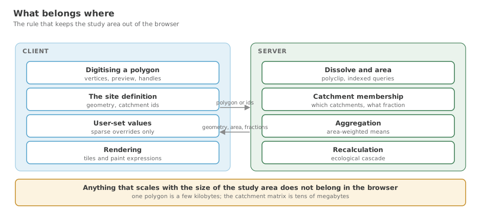
Client: capturing and editing the user's own polygon — vertices, rubber-band preview, drag handles. One shape, a few kilobytes, with no reference to the study area.
Server: anything whose input is the study area — dissolve, area, bounding box, catchment membership, overlap fractions, aggregation — regardless of which creation method produced the polygon.
The second clause is the one that is easy to get wrong. Both site-creation methods converge on the same server-side spatial query; they simply arrive from different directions. Selection sends catchment IDs, digitising sends a polygon, and both receive back {geometry, area, boundingBox, catchmentIds, aoiFractions}.
Digitising a boundary point by point is entirely a client concern. The question asked immediately after digitising — "which catchments does this cover, and by how much?" — is not, and has nothing to do with how the polygon was produced.
flowchart TD
    subgraph Client
        D["Digitise polygon<br/>(vertices, handles, preview)"]
        S["Select catchments<br/>(click on tile features)"]
    end
    subgraph Server
        Q["Spatial query against the study area"]
        Q --> R["geometry, area, boundingBox,<br/>catchmentIds, aoiFractions"]
    end
    D -->|"polygon"| Q
    S -->|"catchmentIds"| Q
    R --> C["Client renders the result"]
What legitimately lives client-side
Every GeoJSON source added in the browser should be the user's own in-progress geometry. There are currently six, and five qualify:
| Source | Content | Size |
|---|---|---|
SiteCreationMap.tsx drawing-preview | rubber-band polygon while drawing | a few vertices |
SiteCreationMap.tsx site preview | boundary being previewed | one polygon |
SiteCreationMap.tsx selected-catchments | catchments the user has clicked | see note below |
MapView.tsx SITE_BOUNDARY_SOURCE | the site outline | one polygon |
MapView.tsx EDIT_VERTICES_SOURCE | vertex handles while editing | a handful of points |
MapView.tsx choropleth-source-* | the study-area matrix | does not qualify |
selected-catchments is a legitimate piece of local interaction state, but its geometry should come from queryRenderedFeatures against the tile the map has already decoded — never from a separate fetch. Once the choropleth is served as vector tiles, those features are available for free.
Client state is a sparse overlay, not the matrix
The only genuinely user-authored analytical data is the values the user typed: ideal and its bounds, and the reference bounds exposed in the indicator editor. Everything else — reference values, current values, catchment areas, AOI fractions — is derived from the datapack and is reproducible on the server from (siteId, catchmentIds).
So a persisted site is its definition plus a sparse override map:
{
  "id": "…",
  "title": "…",
  "geometry": { "type": "Polygon", "coordinates": [ … ] },
  "creationMethod": "drawn",
  "catchmentIds": [ … ],
  "overrides": { "1121879850": { "NPP_gm2": 412.3 } }
}
An override entry costs roughly 40 bytes. A user who edits fifty values across twenty catchments produces about 2 KB.
Store the dense per-catchment matrix instead and the same site costs 27–56 KB per catchment — measured against the tracked walkthrough files. Against a typical 5 MB localStorage quota, a single site of roughly 90–185 catchments consumes all available storage.
The overlay already exists as a temporary
MapView.tsx builds browserIdealOverrides / siteIdealOverrides as Map<catchmentId, number> — exactly the right structure. It is currently derived from the dense matrix by loading the whole thing and discarding all but one attribute, once per attribute, per pane, per colour pass. Promoting it to the stored form is mostly deletion.
localStorage is not a database
Every analytical operation requires the backend in both runtimes. fetchChoroplethData calls /api/choropleth; browser-runtime site creation POSTs to /api/sites/{id}/indicators to have indicators computed. The application cannot function without the server.
Client storage therefore buys no offline capability. Using it as the primary store for derived data is the category error underneath the reported symptoms. Persist user intent; refetch everything else.
Where a site is stored
The rule above is about computation. Persistence has its own rule, and it is not the same one: a user's own sites live in their browser, and are never uploaded.
The runtime decides, via getAppRuntime() in frontend/src/types/runtime.ts. It returns browser unless the Go webview has injected window.__DECISION_THEATRE_WEBVIEW__.
| Operation | Browser runtime | Webview runtime |
|---|---|---|
| Create | saveLocalSites → dt-sites | POST /api/sites |
| Read | loadLocalSites() | GET /api/sites[/{id}] |
| Update | rewrite dt-sites | PUT/PATCH /api/sites/{id} |
| Delete | filter dt-sites | DELETE /api/sites/{id} |
Both halves matter. The desktop build has a filesystem and no quota, so it uses the store in data/sites/. The hosted deployment has neither the right nor the need to hold anyone's work.
Consequences for the API surface
Because no browser session ever calls them, the site CRUD routes are registered only in the desktop build — see registerDesktopSiteRoutes in internal/api/handler.go, gated on config.Config.DesktopMode. POST /api/datapack/install and POST /api/dialog/open-file are gated the same way, for the same reason: both act on the host's own filesystem.
Registering them unconditionally, as we did until this was noticed, put an unauthenticated write-to-disk API on a deployment that nginx proxies wholesale. It was the reachable path behind an arbitrary-file-deletion bug (#29) and a replace-the-data-directory bug (#27).
The routes a browser session does call are a different case and stay public: /indicators, /catchments, /whiskers, /dissolve-catchments and /boundary/*. These accept runtime: "browser" with the site in the request body and return before touching the store — compute in, result out, nothing persisted. Three of them (/indicators/reset, /boundary/union, /boundary/difference) have no such guard, which is exactly why they are gated instead: the client does that work locally in browser runtime and only calls the API from the webview.
The gate depends on a launch flag
DesktopMode is !*headless in main.go. A hosted deployment that stops passing --headless re-opens every route above without a line of Go changing, which is why deployments/Dockerfile and deployments/docker-compose.yaml are asserted to contain it by a test in internal/api.
When adding a route that writes
Ask who calls it. If the answer is "the desktop build", gate it. If the answer is "a browser session", it must not write to disk at all — take the site in the request body and return the result.
Worked example: the two creation paths
Selection → outline (correct today)
POST /api/sites/dissolve-catchments accepts {catchmentIds} and returns {geometry, boundingBox, area}. The client sends IDs and renders the returned GeoJSON. No geometry algebra runs in the browser.
For catchment-selected sites every AOI fraction is 1.0 by construction — each catchment is wholly inside the boundary — so no intersection maths is required at all.
Digitising → catchment membership (currently client-side)
SiteCreationPage.tsx loops over candidate catchments performing, in JavaScript, a turfSimplify, a turfArea, an intersect against the boundary and an overlap-fraction calculation, per catchment.
The backend already implements this: GpkgStore.ApplyAOIFractions(catchments, geometry) takes a polygon and returns per-catchment AOI fractions, against an R-tree-indexed geopackage. The client work duplicates existing Go rather than filling a gap, and it is the reason for the colorTotalFeatures <= 50 cutoff in MapView.tsx, above which the site-catchment set silently comes back empty.
Correctness that degrades with dataset size is the signature of computation sitting in the wrong tier.
Anti-patterns
Geometry algebra in the browser. union, difference, intersect, area and simplify are imported from turf in MapView.tsx and SiteCreationPage.tsx, while Go implements the same operations via polyclip (DissolveCatchments, signedRingArea). Two implementations of the same algebra in two languages, with the slower one running on the user's machine. The comments in MapView.tsx concede the cost directly: "O(n × polygon_complexity) turf.intersect calls that block the main thread."
Bulk geometry as a GeoJSON source. The choropleth is fetched per viewport, parsed on the main thread, tessellated and uploaded — once per map instance, and there are two per pane. This belongs in the tile pipeline. The colour application is already correct and should be preserved: buildFillColorExpression produces a data-driven paint expression applied with setPaintProperty, so colouring happens GPU-side with no per-feature JavaScript. That approach ports directly onto a vector-tile source.
A values table shaped like GeoJSON. valuesOnly responses emit "geometry": null for all 147,837 features, spending 114 bytes to carry one ID and one float. A columnar {ids: [...], values: [...]} carries identical information in roughly a fifth of the bytes. If a response has no geometry, it is not a FeatureCollection.
Sizing reference
Measured against data/datapack.gpkg and the tracked walkthrough files. Reproduce with:
sqlite3 -readonly data/datapack.gpkg "SELECT COUNT(*) FROM catchments_lev12;"
jq '.catchments|length' data/walkthroughs/*.json
| Quantity | Value |
|---|---|
| Catchments in the datapack | 147,837 |
| Indicator keys per scenario, per catchment | 502 |
| Dense per-catchment record | 27–56 KB |
| Sparse override entry | ~40 bytes |
Full valuesOnly response, uncompressed | 16.1 MB |
JSON.parse of that response | ~133 ms (desktop V8, warm) |
| Typical localStorage quota | ~5 MB, counted in UTF-16 code units |
Checklist for new work
Before adding a fetch, a store write or a geometry call, ask:
- [ ] Does this compute something derivable from the datapack? → server
- [ ] Does its input include more than one catchment? → server
- [ ] Is the response a
FeatureCollectionwith null geometry? → make it columnar - [ ] Am I persisting something the server can regenerate? → don't
- [ ] Is this geometry the user is editing right now? → client is correct
- [ ] Does it scale with the size of the study area? → it does not belong in the browser
- [ ] Does it write to disk? → then no browser session may call it; gate it on
DesktopMode(above)