Introduction
The Open Source GIS Stack by Kartoza is maintained in the kartoza / osgs repository.
What is the Open Source GIS Stack?
In the open source geospatial world, there are different interesting technologies that have been developed to allow one to manipulate, visualize, publish, manage, edit, etc. geospatial data. These technologies are often in disparate projects. Programs like the QGIS project, are often ensemble applications that take some of these different technologies as components and use them to provide some higher level functionality. In some cases the integration is in silos or vertical applications, for example QGIS, PostGIS, Geoserver, etc. The aim of this project is to take a number of those different silos and incoporate them into a single platform, therefore making it really easy to access and publish the different types of services that are easily available on their own but not so easily available in a consolidated platform.
The Open Source GIS Stack (OSGS) is a platform based on Docker, which is a container deployment environment. Containers are isolated application runtimes. They typically contain a minimal version of an operating system, typically Linux. In that minimal version of the operating system the containers will typically have one single task they are responsible for doing, for example running PostGIS or running Geoserver and so on. Each container has a very specific task and the design intent that you do not deploy mutliple services in a single container. You must deploy each service in its own container then orcherstrate those containers together. This is all managed using Docker and Docker Compose which is the orchestration environment for Docker. OSGS is simply a set of Docker orchestration routines to bring up different services in different containers, make them all talk together and present them as one cohesive architecture.
The Open Source GIS Stack (OSGS) is a platform based on Docker, which is a container deployment environment. Containers are isolated application runtimes. They typically contain a minimal version of an operating system, typically Linux. In that minimal version of the operating system the containers will typically have one single task they are responsible for doing, for example running PostGIS or running Geoserver and so on. Each container has a very specific task and the design intent that you do not deploy mutliple services in a single container. You must deploy each service in its own container then orcherstrate those containers together. This is all managed using Docker and Docker Compose which is the orchestration environmnt for Docker. OSGS is simply a set of Docker orchestration routines to bring up different services in different containers, make them all talk together and present them as one cohesive architecture.
The other important thing that OSGS does, is it provides some scripts to do various management commands and tasks, for example, bringing up services or down services, copying data, making backups, etc. These scripts are provided using a utility called “make” which is typically used by programmers to compile software, but can also be used to automate tasks. There is a Makefile which does all the high level tasks on the orchestrated architecture that OSGS provides.
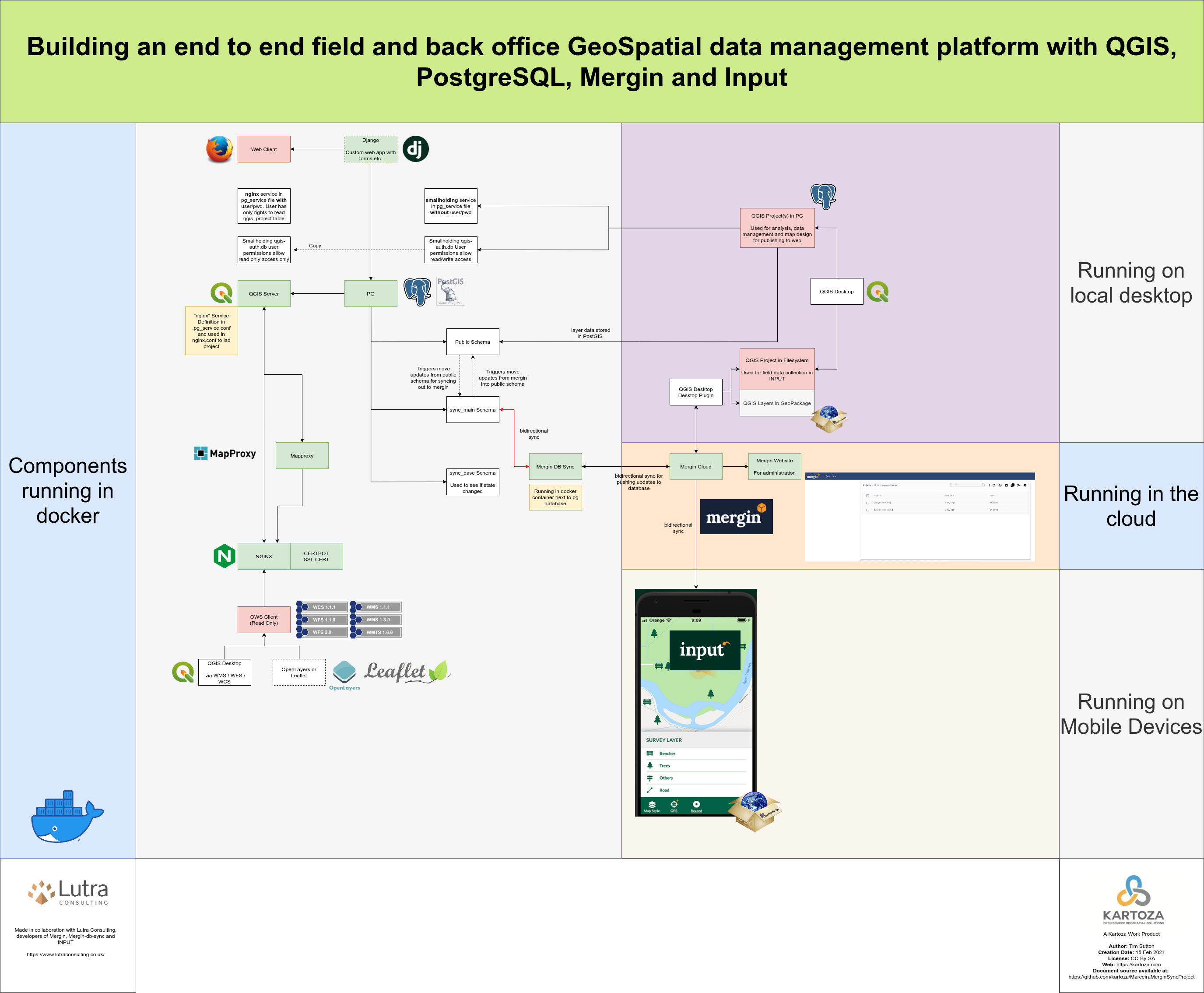
Overview Diagram
Note: Anybody can take open source software and package it as Docker services. Therefore, when you are choosing which Docker service and containers to run, you can go and have a look at the various ways different people have packaged up a particular software and find one that works the best for you.