Data Preparation
Before uploading data to GeoSight, it’s important to ensure that both your spatial datasets and indicator data are correctly structured. Proper data preparation ensures smooth imports, accurate mapping, and reliable dashboard performance.
Reference (Spatial) Data
Reference datasets define the geographic boundaries used to display your indicator data (e.g. countries, provinces, districts). These are typically uploaded as shapefiles (.shp zipped) or other supported formats.
Each administrative level must include specific required fields:
| Level | Required Fields | Description |
|---|---|---|
| Level 0 | ucode, name | Unique code and name for each feature (e.g. Country) |
| Level 1 | ucode, name, level_0_ucode | Includes a reference to the parent, Level 0 (e.g. Province) |
| Level 2 | ucode, name, level_1_ucode | Includes a reference to the parent, Level 1 (e.g. District) |
Important notes:
- The ucode must be unique for each feature.
- Parent codes (e.g. level_1_ucode) must match existing codes in the higher level dataset.
- Field names should match exactly to avoid import issues.
Indicator Data
GeoSight supports multiple data sources, including:
- APIs (JSON)
- Excel files
- SharePoint Excel
- SDMX Data Warehouse
The easiest method is importing data via Excel. Two formats are supported:
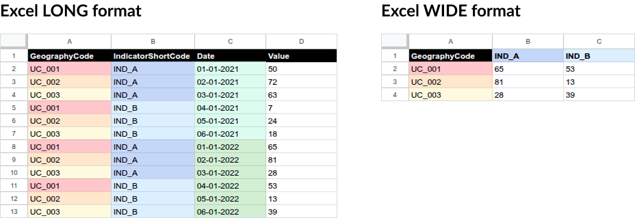
Excel LONG Format
Best for handling multiple indicators, locations, and time periods in a single file.
Required columns:
| Column | Description |
|---|---|
| GeographyCode | Links to the ucode in your reference dataset. |
| IndicatorShortCode | Must match the indicator shortcode in GeoSight. |
| Date | A valid date (e.g. 01-01-2022). |
| Value | The recorded value. |
Excel WIDE Format
Best for multiple indicators at a single point in time.
Required columns:
| Column | Description |
|---|---|
| GeographyCode | Links to the ucode. |
| Indicator columns | Column names must match indicator shortcodes (e.g. ABC123). |
| Value | The observation values. |
Data Preparation Workflow
Preparing your data follows a simple process:
- Prepare your reference dataset (boundaries with correct fields)
- Define your indicators (what you want to measure)
- Format your data (Excel LONG or WIDE)
- Ensure alignment between GeographyCode and ucode
- Validate your data before importing into GeoSight

Next up: Learn how to prepare and upload Reference Datasets in GeoSight.